02 October 2013
On our first Thursday, March 17th (see below for explanation) we finished our planned line of stations 525 nautical miles straight south from 67°S (roughly the Antarctic Circle) to the Antarctic continental shelf, stopping every 30 miles to make measurements. This completes for the first time the southern end of a long transect of oceanographic measurements extending from Kodiak Island, Alaska, to Antarctica, known to oceanographers as "line P16". This also completes a key portion of our intended work on this cruise, though there is a great deal more work to do. Data quality remains excellent, and all systems are working well, except that one of the two lowered Acoustic Doppler Current meters (LADCP) is out of service, limiting LADCP profiles now to downward-looking only.
See the attached figure, and its caption below, from Alex for a discussion of some of the scientific findings apparent when comparing the 2011 data with those from earlier years.
We have all enjoyed the good weather. The last group of 5 closely-spaced stations were carried out in highly varied and increasingly more impressive ice ranging from the smallest newly-formed frazil ice that "greases" the sea surface, to new "pancake ice" of various sizes (very easy going), to first (easy) and multi-year (try to avoid) sea ice, to impressively thick pieces of broken off ice shelf (impossible), to mighty icebergs (likewise). The Palmer's mates and our expert ice pilot Vladimir Repin enjoy the challenge of guiding the ship through the maze of ice day and night. The Nathaniel B. Palmer's large bridge has great all-around views and is The Place To Be when one has a bit of time off, though the weather has been so good that some have bundled up and to watch icebreaking from the bow or other points outdoors on the ship. The ice and icebergs provide many photo opportunities and we frequently come across penguins and basking seals.
We are at the edge of the footprints of both of the geosynchronous INMARSAT satellites (one over the Atlantic equator and the other over the Pacific equator) that provide our primary email communications, so email may continue to be a bit sporadic until we head back north to the S04P line at 67°S. Although we did our date line crossing some time ago we saved our day/date change to celebrate St. Patrick's Day (Thursday, March 17th) twice on the ship.
Our cruise is now approximately at its half-way point. We are steaming toward the sites where we will recover two strings of moored instruments co-chief scientist Alex Orsi deployed February 2010. We will then resume our CTD work with our third crossing of the Antarctic continental slope. Weather has been good to outstanding most of the past week, and during our few days in the ice all hands enjoyed the wildlife and highly-varied ice. New ice is forming around us, with grease ice consolidating in sheets and pancakes. Meanwhile we motor around magnificent icebergs and slab-like chunks of shelf edge ice.
We continue to enjoy working with our team at sea. This may be a very long cruise but with this team it is a productive and happy one. The entire ship's company continues to work with expertise, efficiency, and good cheer. All is well aboard the Nathaniel B. Palmer.
We have included Nancy Williams' photo of an iceberg at sunset (See above left) and Wilson Mendoza's photo of a group of Adelie penguins (See above right).
Jim and Alex
") Group of Adelie penguins (Wilson Mendoza)
Group of Adelie penguins (Wilson Mendoza)") Iceberg at sunset (Nancy Williams)
Iceberg at sunset (Nancy Williams)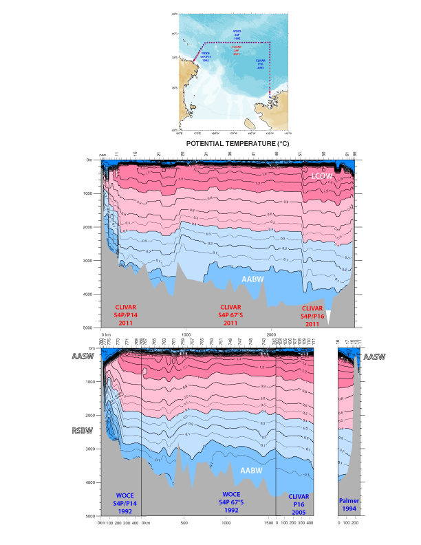 Figure and caption from Alex Orsi.
Caption: a) Location map with stations occupied during the 2011 S04P repeat (red) and in previous cruises (blue) of 1992 (WOCE), 2005 (CLIVAR) and 1994 (N.B. Palmer); b) synoptic vertical section of potential temperature (°C) on CLIVAR S04P 2011; and c) on a multiyear composite from the older hydrography.
Data from the just completed Antarctic coast-bound transect enclosing the southwestern Pacific Ocean, partly due to unprecedented spatial and temporal resolution, reveal a series of mesoscale to large-scale circulations. A southwestward loop of the Antarctic Circumpolar Current is found across the southern half of the 150°W line. Significantly warmer source Lower Circumpolar Deep Water (LCDW) now enters the interior subpolar cyclones found around the Balleny Islands and to the south of the Southwest Pacific Ridge. Prominent westward flow associated with the Antarctic Slope Current is revealed just upstream and downstream of the Ross Sea, near Cape Colbeck and Cape Adare. The Antarctic Surface Water (AASW) carried farther inshore has cooled and freshened over time between the repeat hydrography. Evolving characteristics in the LCDW, AASW and Shelf Water mixtures outflowing the Ross Sea are evident in the deep and bottom layers of the S04P line. E.g. on average the AABW recirculating below 3000 m in this region has increased its temperature by about 0.1°C.
Figure and caption from Alex Orsi.
Caption: a) Location map with stations occupied during the 2011 S04P repeat (red) and in previous cruises (blue) of 1992 (WOCE), 2005 (CLIVAR) and 1994 (N.B. Palmer); b) synoptic vertical section of potential temperature (°C) on CLIVAR S04P 2011; and c) on a multiyear composite from the older hydrography.
Data from the just completed Antarctic coast-bound transect enclosing the southwestern Pacific Ocean, partly due to unprecedented spatial and temporal resolution, reveal a series of mesoscale to large-scale circulations. A southwestward loop of the Antarctic Circumpolar Current is found across the southern half of the 150°W line. Significantly warmer source Lower Circumpolar Deep Water (LCDW) now enters the interior subpolar cyclones found around the Balleny Islands and to the south of the Southwest Pacific Ridge. Prominent westward flow associated with the Antarctic Slope Current is revealed just upstream and downstream of the Ross Sea, near Cape Colbeck and Cape Adare. The Antarctic Surface Water (AASW) carried farther inshore has cooled and freshened over time between the repeat hydrography. Evolving characteristics in the LCDW, AASW and Shelf Water mixtures outflowing the Ross Sea are evident in the deep and bottom layers of the S04P line. E.g. on average the AABW recirculating below 3000 m in this region has increased its temperature by about 0.1°C.